Kodaikanal Tourism
ACTIVITIES
Things to Do in KODAIKANAL - Kodaikanal Sightseeing - Kodaikanal Weather
We provide Kodaikanal sightseeing as per your request (sightseeing package rates are applicable)
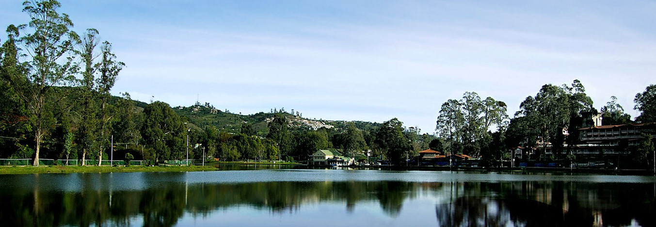
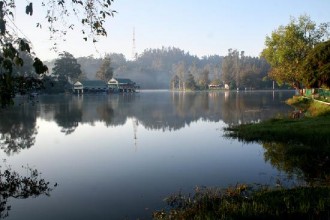
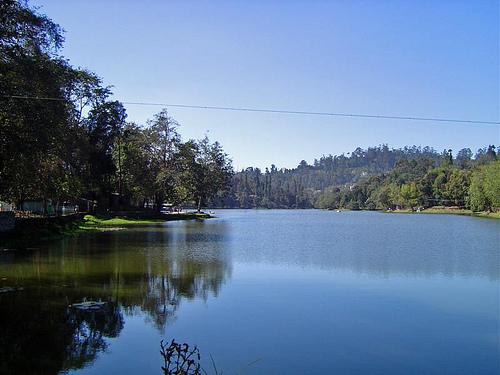
Kodaikanal Lake, also known as Kodai Lake is a manmade lake located in the Kodaikanal city in Dindigul district in Tamil Nadu, India. Sir Vere Henry Levinge, the then Collector of Madurai, was instrumental in creating the lake in 1863, amidst the Kodaikanal town which was developed by the British and early missionaries from USA. The lake is said to be Kodaikanal's most popular geographic landmark and tourist attraction. Over the years a boat club, boathouse and boat service (with rowing boats and pedalling boats and a public ferry) for the public and tourists has become fully functional and is of aesthetic significance for tourism. Boat Pageant and Flower Shows are a regular feature in the summer season which attracts tourists.
Berijam Lake is a reservoir near Kodaikanal town in Dindigul district of Tamil Nadu, South India. It is at the old site of "Fort Hamilton", in the upper Palani hills. The lake, created by a dam with sluice outlets, is part of a micro–watershed development project. Periyakulam town, 18.7 kilometres (11.6 mi) to the SE, gets its public drinking water from the lake. The lake’s water quality is excellent. Berijam is located at the end of Pillar Rocks Road (old SR-18), 21 km (13.0 mi) southwest of Kodaikanal Lake. map There were two roads from Berijam, the Kodaikanal–Munnar Road to Munnar town, about 40 km (24.9 mi) west and another going to Kavunji village, 9 km (5.6 mi) north. The old roads are now overgrown with vegetation and used as walking trails by local villagers and trekkers. Encounters with wild animals including bison, elephants and leopards sometimes occur on these trails. The Tamil Nadu Forest Department has restricted entry into the Berijam Lake area to between 9.30 a.m. and 3 p.m. for the general public. Entry permits are issued at the Forestry Department Office in Kodaikanal. Only a limited number of visitors are allowed in the park each day. There is a forest check–post which prohibits unauthorized entry through the road leading to Berijam Lake. Beyond km marker 13 on the Berijam road there is an observation tower from where one may have a fine view of Berijam Lake and the surrounding forest. Berijam has a Forest Department Camp including an Eco-Education Center for visitors. Nature areas to be visited here include: swamp ecosystem, fresh water ecosystem, nature trail, bridge, medicinal demonstration garden, museum, nature walk, grassland and shola. Site visits are organized for authorized researchers. Trekkers can get permission to stay overnight. There is a Forest Rest House with limited accommodations which serves as an overnight base camp for Forestry Department staff, researchers and trekkers. Visitors must bring their own provisions.
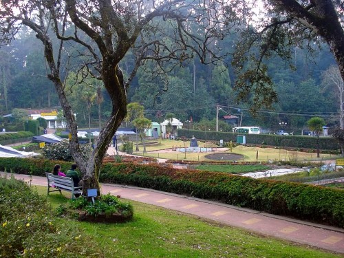
Bryant Park, seen on the lake's eastern side, 3 kms from Lake is another important botanical park that must not be missed by tourists visiting Kodaikanal as it houses plenty of different varieties of flowers, rafts as well as hybrids. A British forest officer by the name Bryant was the one who landscaped this park in the year 1980 and hence it is named after him. This is the place where the annual vegetable and flower show is held during the month of May and is the most visited place by many during the summer months. A glasshouse in the park contains wide varieties of flowers, ferns and other ornamental plants. The practical utility of this park is, in every May a horticultural show is conducted by the department of Horticulture. On that occasion enormous vegetables and flowers from neighbouring villages compete for the prizes, which draws big crowd. They exhibit flowers, vegetables, fruits and other products. It serves as a practical centre for education on Ornamental Horticulture and as a demonstration centre. The various methods of training, pruning, budding, grafting, potting seed collection etc, are taught to the students of Horticulture as well as to the visitors.
Chettiar park, managed by the township, is on the way to the Kurunji Temple. It is 3.2 kms from the Bus Stand. Unlike other areas this park is very quite, and those who love calm timepassing can prefer this park. CHETTIAR PARK - A Precise Garden", which is just a stones throw away fromthat temple. It is a beautifully landscaped park in one corner of the Kodaikanal town. Being distinct from other commercialised areas, this park is vey silent and you can unwind yourself in a world of serene and peaceful. Carefully maintained decked floors for flowering plants, beautifully designed bushes, huge variety of fascinating flowers, well developed lush green grass meadow and the bracing breeze make the ambiance fresh. Hence it became "a pleasing tourist spot". The visitors will be allowed here for free. It was a queer experience roaming over there and everyone will find themselves enjoying the experience.
The Hill Temple of Pazhani is one of the most famous temples of Murugan in India. It is 65 kms from the Kodaikanal Lake. It is located in the town of Pazhani, 100 km southeast of Coimbatore and a similar distance northwest of Madurai, and in the foot-hills of the eponymous PazhaniHills. At its foot is the Temple of Thiru-avinan-kudi, one of the Arupadaiveedu. Priests of these ancient Temples accept and agree that the ancestors of DevendraKulathar are the ancient Tamil Kings namely Chera, Chola, Pandiya.There are ownership documents (Pattayam signed during the 1500s) that show that the Palani Murugan Temple and numerous ancient Temples belong to people of Devendrakulam. The Temple is situated upon the higher of the two hills of Palani, known as the Sivagiri. Traditionally, access to it was by the main staircase cut into the hill-side or by the yanai-padhai or elephant's path, used by the ceremonial elephants. Pilgrims bearing water for the ritual bathing of the idol, and the priests, would use another way also carved into the hill-side but on the opposite side. Over the past half-century, three funicular railway tracks have been laid up the hill for the convenience of the pilgrims, and supplemented by a rope-way within the past decade. The sanctum of the temple is of early Chera architecture while the covered ambulatory that runs around it bears unmistakable traces of Pandya influence, especially in the form of the two fishes, the Pandyan royal insignia. The walls of the sanctum bear extensive inscriptions in the old Tamil script. Surmounting the sanctum, is a gopuram of gold, with numerous sculptures of the presiding deity, Kartikeya, and gods and goddesses attendant upon him. In the first inner prahāram, or ambulatory, around the heart of the temple, are two minor shrines, one each, to Shiva and Parvati, besides one to the Sage Bhogar who is by legend credited with the creation and consecration of the chief idol. In the second outer prahāram, is a celebrated shrine to Ganapati, besides the carriage-house of the Lord's Golden Chariot.
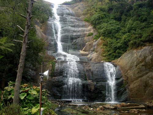
Silver Cascade Falls is the first attraction that welcomes the tourists to Kodaikanal on the Madurai - Kodai road, situated on the main Ghat road. Silver Cascade Falls is 8 kms before Kodaikanal as you approach Kodai from Kodai Road. Silver Cascade Falls, a picture perfect spot to explore in Kodaikanal was famous for its clean, pure and glittering water once and resulting in the name Silver Falls. The spillover of Kodaikanal Lake takes a 180 ft dive over a vertical cliff, to sprint into a pool adjacent to the Ghat Road. The excess water from the Kodai Lake flows downward as a fall at about 8 kms from Kodaikanal. This waterfall is pleasing and stimulating during the monsoon when the water is in full flow. There are few shops selling fruits and other forest products making this point a pit stop for travelers and tourists crossing this road. Silver Cascade falls is 180 feet high and the bubbly water flowing downhill over the rocks piles will mesmerize any tourist. The crystal clear water restrains various minerals. A refreshing bath in this soothing falls would be mind-blowing. Sitting and enjoying the beauty of the silver cascade falls for hours has been a preferred time pass for most of the tourists to Kodaikanal. The quality of the water has been turning poor off late and not fine enough for bathing. This remarkable waterfall is a famous stop for first-time tourists on Kodaikanal tour. The monkeys here make the Silver Cascade falls a pleasing place for children's. There is also a smaller but more serene waterfall below the bridge which crosses the stream here. During the rainy season the water flow increases by volume and roars down in startling cascades and is a treasured experience. It is wonderful roadside scenery not to be missed en route to Kodaikanal. The authorities have been allowing the tourists take a quick bath here earlier. However, off late the Cascade area is compounded and a small park has been developed around it, making it fine for a few minutes break of travel and photography.
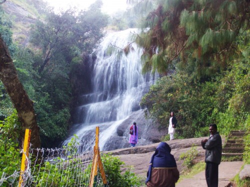
Bear Shola falls is an elevated waterfall in the reserve forest sited 3 kilometres (1.9 mi) away from Kodai bus-stand. Bear Shola falls is a wonderful touring spot in Kodai within 2 Kms from the lake, which was drinking resource of the bears in the forest once. The final sketch close to this hushed Bear Shola falls is a restfully hiking trek. It is quite ideal for a day's outing. It is the base of the river which takes the name of Parappar and later Tevankarai Aar as it streams downhill. The Bear Shola Falls is a supreme place to visit through the showers to take pleasure of the nature and god's creation. You will have to cross a craggy trek to reach this falls hence suitable mode of transport would be essential. The Shola forest around will beckon the wildlife enthusiasts. A concrete path has been laid for short trekking into the deeper backwoods. Bear Shola falls is sited at a 3 km distance from the Kodaikanal bus stand inside a reserve forest. Besides the late monsoon season there may not be much water flow, however a 1 km trek into the forest until the falls is an impressive experience.
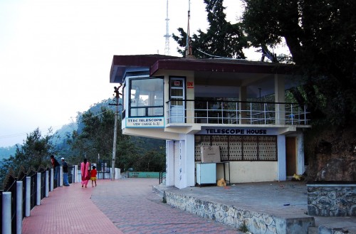
A Telescope House has been placed on the northern tilt of the Coaker's Walk which has been designed for the benefit of the sightseers. The Kodaikanal Terrestrial Telescope is proficient in covering a extensive scene including: Sothupparai Dam, Vaigai Dam, Periyakulam and Varaha river. A telescopic sight of outlying valleys and villages, through the clear daylight, offers a great experience to you. The telescope is quite powerful and well placed and a nominal fee is collected for using it.
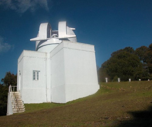
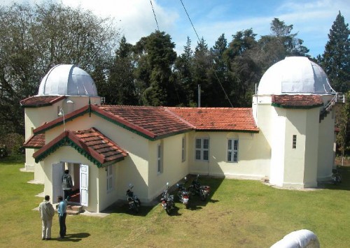
The Kodaikanal Solar Observatory is a solar observatory owned and operated by Indian Institute of Astrophysics. It is located on the southern tip of the Palni Hills 4 km from Kodaikanal town, Dindigul district, Tamilnadu state, South India. The Evershed effect was first detected at this observatory in January 1909. Solar data collected by the lab is the oldest continuous series of its kind in India. Precise observations of the equatorial electrojet are made here due to the unique geographic location of Kodaikanal. Ionospheric soundings, geomagnetic, F region vertical drift and surface observations are made here regularly and summaries of the data obtained are sent to national IMD and global WMO GAW data centers.
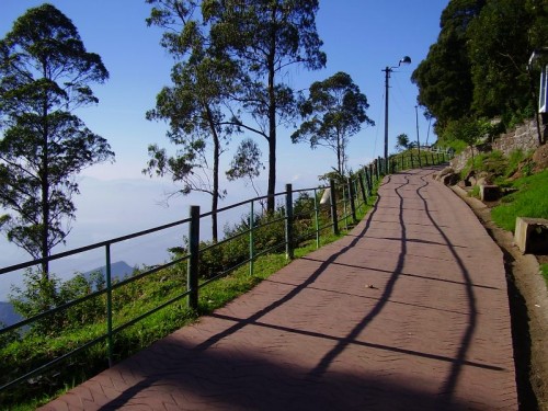
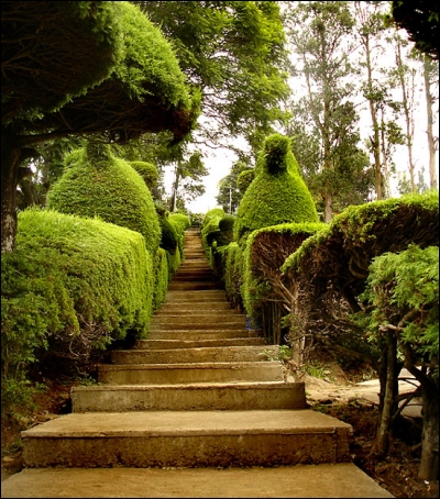
Coaker's Walk is a magnificent gift of Mother Nature to Kodaikanal and its tourists. Coaker's walk is just 1 km from the Kodai Lake which provides an amazing picturesque view of the plains as well as scenic valleys making the moments the most memorable of your life. Coaker's walk derives its name from Lt. Coaker, who had prepared the map of Kodaikanal.Coaker's Walk lies along a sheer slope on the southern side of the Kodai. Several best views of the plains can be seen from here. It is a narrow one kilometer walking pathway on the mountain road, built by Lt. Coaker in the year 1872, winding around mt. Nebo starting close to van Allen hospital and ends at the main road above St. Peter's Church providing a wide-angle stunning view of the plains. On a bright clear day you can view some of the interesting sights, such as.... Dolphin's nose in south, valley of the Pambar River in South East, bird's eye view of Periyakulam and even the city of Madurai. There is a Telescope House half way the Coaker's walk. This is to facilitate the visitors to have a panoramic view of the deep valley and its surroundings, which should not be missed by the tourists visiting the place.
Dolphin's Nose is an incredible design of nature's magnificence - A smooth protruding rock at the edge of the cliff, above an immense depth of close to 6600 feet seizes your breath away on the occasion. Dolphin's Nose is sited 8 km far from the Berijam Lake, at Kodaikanal. Seven kilometers since the Kodaikanal Lake, a inquisitive natural configuration of rock, alike the nose of a dolphin jutting out above a deep valley. The vicinity of Periyakulam town and Vaigai Lake are evidently noticeable on clear days. You can get to this point by a one kilometre trekking from Vattakkanal settlement till where small motor vehicles can go. The summit is 1960 metres above sea level. There is a adjacent echo-point from where sound yells or screams will produce reverberations in the form of numerous echoes.
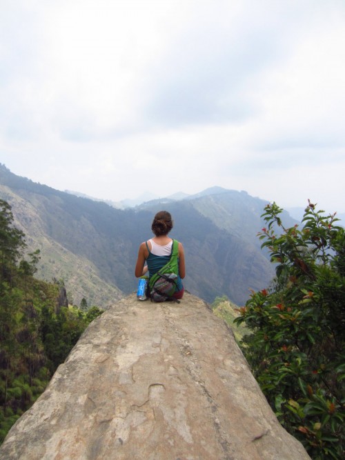 To reach Dolphin's nose, you will have to follow the old road shortly after crossing Pambar Bridge near parting stream. An uneven arc encircling the hillside which takes you to a point where a flat rock ventures over an appalling gulf of 6600 feet deep. The elderly community of Vellagavi is accessible through the rocky restrained trak. Please ensure that you wear comfy footwear as you trek through the forest area. There are ample of petite shops on the way selling refreshments. The pathway through has various thrilling viewpoints giving a panoramic view of the forest roofed by the clouds. The climate is more pleasing between October and March as Sun sneaks through these woods adding a new dimension to its splendor. It's out of the world experience to rest on the cliff of the rock. You will take pleasure in the most exciting and terrifying instants of life as you get close to the Dolphins nose. Clouds pass through you making you sense the fresh air through your lungs. Mountains around are mostly covered by clouds. You have to certainly visit this location during your KodaiKanal tour. The name comes from its apparent similarity of a Dolphin's nose. (There is a similar rock and place in Ooty too called by the same name). This is an overwhelming site though we have amazing sites throughout the way. This is one of the key noteworthy sites in Kodai to explore the forest around. Grab spectacular views of the hillside standing on the cliff of the rock. The complete environs are enclosed with clouds most of the time. A riveting experience undeniably.
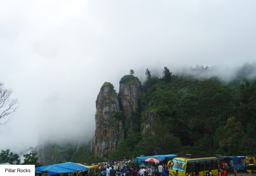
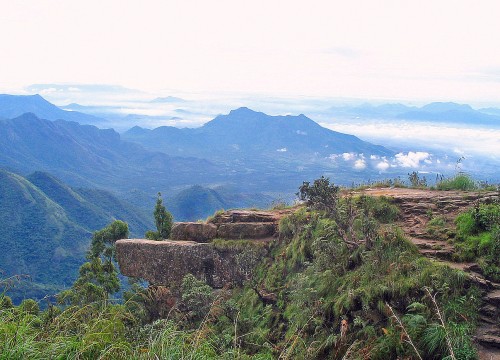
The Pillar rocks are three precisely twisted erect huge rocks footing shoulder to shoulder, rising from the abundant valley measuring 122 meters high, a splendid site to gaze at. It is positioned 7.4 kms from the Kodaikanal Lake. These giant rocks measure about 400 feet high from the ground and the chambers between the pillars are recognized as the Devil's Kitchen. The Pillar Rocks have grown-up in fame as the days have passed by. During the crest season you can see enormous crowd of guests to this place. The speckled woods in the vicinity of these massive boulders are a enormous point to enjoy your Kodaikanal tour. The sightseers can view these rocks footing from a relaxing vantage point where a garden has been developed. The fleet progress of intense fog across the rocks, covering and exposing the Pillar Rocks from view, off and on, is appealing and lovely. Caves, chasms and thick trees in the outline of the rocks magnetize the audacious.
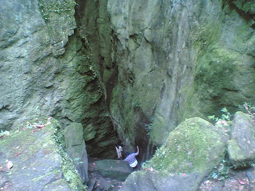
Devil's Kitchen is an exceptionally treacherous subterranean veiled narrow valley that bears a resemblance to a small dark trench but is a deep fall in reality, 6 kms away from Lake. These are consequential peculiar rock formations due to wearing down of the loam from the cliffs. Tiny trekking up on the adjacent hill will give panoramic views of valleys deeper than 1500 feet below. Small wild animals and several birds can be seen here. The Devil's kitchen or Guna cave has become one of the most favorite spots for tourists visiting Kodaikanal. Hope you don't miss exploring this point on your trip to Kodaikanal. The Devil's kitchen is undoubtedly an exciting place to explore mixed with a bit danger. Once a troop of 12 got deeper into the cave and never returned it seems. To reach to this place take a turn from Pillar Rocks at the road leading to Berijam Lake, where you will find a small walk through the pine forest past which you can reach the Devil's Kitchen or Guna Caves. The Devil's Kitchen is found to be lying between the Green Valley View point and the Pillar Rocks. A local person to guide you while visiting the Devil's Kitchen would a wise choice sine they would be absolutely conscious of the geography of this place. It stand as an excellent spot for taking pictures and film making, on the other hand, some tourists skip the visit to this place considering the deep fall. The Devil's Kitchen is otherwise called as Guna cave, a deep bat-infested hollow place between three naturally arranged impressive boulders (Pillar Rocks). Devil's Kitchen got the name Guna Caves after it turned to be a romantic hijacker's lair for the Tamil movie Guna. Young people chanter angstful "Abiramiiiii!"s standing just outside the fencing around the cave.
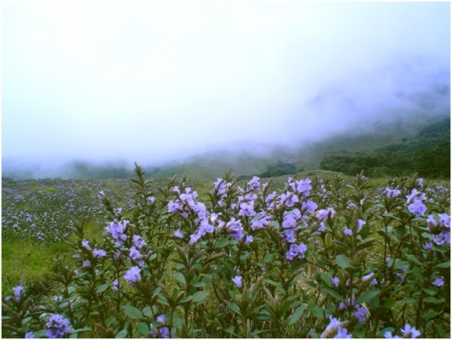
Neelakurinji (Strobilanthes kunthiana) (Malayalam: നീലക്കുറിഞ്ഞി) (Tamil: நீலக்குறிஞ்சி), is a shrub that used to grow abundantly in the shola grasslands of the Western Ghats in South India above 1800 metres. The Nilgiri Hills, which literally means the blue mountains, got their name from the purplish blue flowers of Neelakurinji that blossoms gregariously only once in 12 years. The Paliyan tribal people apparently used it to calculate their age. This plant belongs to the genus Strobilanthes which was first scientifically described by Christian Gottfried Daniel Nees von Esenbeck in the 19th century. The genus has around 250 species, of which at least 46 are found in India. Most of these species show an unusual flowering behaviour, varying from annual to 16-year blooming cycles; on the national scale there is often confusion about which plant is flowering. Plants that bloom at long intervals like Strobilanthes kunthiana are known as plietesials. Other commonly used expressions or terms which apply to part or all of the plietesial life history include gregarious flowering, mast seeding, and supra-annual synchronized semelparity (semelparity = monocarpy).
Kodaikanal Trekking Routes:
Kodaikanal is a paradise for trekking lovers as it offers different trekking routes for the professional trekker to the novice trekker as well. Trekking routes with varying difficulty levels are there and a tourist can select the route according to the fitness, time factor and one's trekking ability.
- Kodaikanalkanal-Batlagundu (55 Km): Law's Ghat Road.
- Perumalmalai-Palamalai(8km) - Thalayar (90 mins.) - Manjalar (150 mins.)-Devadanappatty(6km).
- Shembaganur-Korappur-Adukkam(180 mins.) - Selumbathope (120 mins.) - Kumbakkarai - Periakulam (10km).
- Shembaganur-Vengayapparai (Coolie or telegraph path); A.G.Bourne's "Kodaikanalkanal Ghat" (4 hours)-Kumbakkarai - Periakulam (10Km).
- Kodaikanalkanal-Dolphin's Nose-Vellagevi-Vengayapparai (left of Vellagevi) (300 mins.)-Kumbakkarai-Periakulam(10Km.).
- Kodaikanal-Dolphin's Nose-Vellagevi-Kumbakkarai (right of Vellagevi) (300 mins.)-Kumbakkarai-Periakulam (10 Km).
- Kodaikanal-Green Hut (12Km) (along the ridge for 30 mts) - down to Chinnur-Periakulam (300 mins.)
- Kodaikanal-Thoppithookkipparai (near Berijam) (16Km) - Periyur (3 hours) - Sothupparai - Periakulam (10 Km).
- Kodaikanal-Karthirikkai Odei (40Km) - Sinna Sothupparai - Athirikkarappankoil - Oral muthu - Valasal aaru - Bodinayakanur (6 hours).
- Kodaikanal-Berijam (23 Km) - Konalar (5 Km) - Sebastian Odei (3 Km) - Marion Shola (2Km) - Kathirikkai Odei (1 Km) - Kambippalam (3 Km) - Pulavachiar (5 Km) - Vandaravu (10 Km) - Top Station (10 Km) - Central Station (2 hours)- Kurangani (Bottom Station) 3 hours - Bodinayakanur (17 Km).
- Kodaikanal - Mannavanur (35 Km) - Keelanavayal (90 mins.) - Manjampatty (3 hours) - Thalinji (2 hours) - Champaked ( 90 mins.)-Chinnar (5 Km) - Udamalpet (32 Km) - Palani (37 Km).
- Kodaikanal - Paricombai (27 Km) - Kukkal (8 Km) - Kuthirayar-Pappanpatty-Kavalapatty (7 hours) - Palani (23 Km.)
- Kodaikanal - Puthur (43 Km) - Bonthampally (24 mins.) - Kavalppatty (9Km) - A-Kalaiamputhur (9Km) - Palani (5 Km.)
- Kodaikanal - Pallanghi (10 Km) - Thalamalai - Porandalar-Palani.
- Kodaikanal - Vilpatty (8 Km) - Ganesapuram-Puliamarathope (240 mins.) - Palani (13 Km).
- Kodaikanal - Perumalmalai (13 Km) - Pethupparai (6 Km) Ganesapuram-Puliamarathope (240 mins.) - Palani (13 Km).
- Kodaikanal - Perumalmalai-Palani Ghat road (60 Km).
- Kodaikanal - Tandigudi (40 Km) - K.C.Patty (20 Km) - Asarippatty - Bethelpuram-Parappalar-Thalayoothu - Viruppachi.
- Kodaikanal - Tandigudi (40 Km) - K.C.Patty (20 Km) - Pachalur (10 Km) - Oddanchatram (31 Km).
- Kodaikanal - Tandigudi (40 Km) - Adalur (15 Km) - Panrimalai (4Km)-Alagumalai (5 Km) - Puducombai (14 Km) - Karisalpatty (7 Km) - Vattapparai (4Km) - Melpatty (2 Km) - Anandarayamkottai-Pithalapatty (2Km) - Dindigul (7Km.)
- Kodaikanal - Tandigudi (40 Km) - Thadiankudisai (10 Km) - Batlagundu (33 Km.)
Geography
4U Resort, Kodaikanal is a city in the hills of the taluk division of the Dindigul district in the state of Tamil Nadu, India. Its name in the Tamil language means "The Gift of the Forest". Kodaikanal is referred to as the "Princess of Hill stations" and has a long history as a retreat and popular tourist destination.
1955 Topographic map of Kodaikanal
The town of Kodaikanal sits on a plateau above the southern escarpment of the upper Palani Hills at 2,133 metres (6,998 ft), between the Parappar and Gundar Valleys. These hills form the eastward spur of the Western Ghats on the Western side of South India. It has an irregular basin as its heartland, the centre of which is now Kodaikanal Lake a 5 kilometres (3.1 mi) circumference manmade lake.
Meadows and grasslands cover the hillsides. Gigantic Eucalyptus trees and shola forests flourish in the valleys. Mighty rocks and cascading streams. rise up from the valleys. There are many high waterfalls and ubiquitous gardens and flower beds in bloom.
Kodaikanal is known for its rich flora. Of the big trees, cypress, eucalyptus and acacia are the dominant varieties. Pear trees are numerous and the fruits are of high quality. Competing with the fruit trees are the flowering ones - mainly rhododendron and magnolia. Large dahlias of different hues are the main attraction of Bryant Park, situated close to the Kodai lake. Water lilies in the park's pond are another pleasing sight. The town abounds in a kind of beautiful yellow wild flowers.
North of the town, high hills that slope down into the villages of Pallangi and Vilpatti stand guard. On the east the hill slopes less abruptly into the lower Palnis. A precipitous escarpment facing the Cumbum Valley is on the south. On the west is a plateau leading to Manjampatti Valley, Indira Gandhi National Park, the Anamalai Hills and the main body of the Western Ghats.
WEATHER FORECAST
Education
The following schools are located at Kodaikanal: Bhavan's Gandhi Vidyashram, Brindavan Public School, Kodaikanal International School, Kodaikanal Public School, St. John's Girls Higher Secondary School, St. Joseph's Public School, St.Peter's Matriculation Higher Secondary School, St. Xavier's High School, Zion Matriculation High School,Sankara Vidhyalaya.
The main colleges here are: Kodaikanal Christian College, which is the first Arts and Science College in Kodaikanal established in the year 1994, ever since, the college has committed to impart holistic education and transforming students into model global leaders, the strong alumni is the evident of it. (American University of India (AUI) / Kodai International Business School (KIBS) www.auiedu.com) which is an elite Business school offering MBA & BBA programs in USA & India located in Ugarthenager. Sacred Heart College. Mother Theresas University is distinctive as India's only university devoted to exclusively women's issues.[36][37][38] In 2005 a new engineering college specializing in Information Technology, Kodaikanal Institute of Technology under Anna University, has been established 22 kilometres (14 mi) below Kodaikanal town.